In the spring of 1852, William Nobles convinced the merchants of Shasta City, near present day Redding, California, that he had discovered a viable wagon road to their thriving town. Nobles proceeded to show them the new wagon route that initially branched off the Applegate Trail at Black Rock and headed southwest across the Black Rock and Smoke Creek Deserts to Honey Lake Valley and Susanville. From there the trail continued westerly through forested and volcanic country, finally descending to the upper end of the Sacramento Valley at Shasta City. The Nobles Trail proved to be one of the easiest of all the wagon routes into northern California and received heavy use in subsequent years. For more information on the opening and development of the Nobles Trail, see Trails West’s A Guide To The Nobles Trail. Enjoy your photo tour of this historic emigrant trail.
NOBLES TRAIL PHOTO TOUR

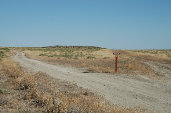
BEGINNING OF THE TRAIL – MARKER N-1
Beginning in 1854, the Nobles Trail branched off the Applegate Trail approximately one mile west of Rabbit Hole Springs. Between 1852 and 1854, the Nobles Trail left the Applegate Trail at Black Rock Springs. In the photo above, the road on the right is the Applegate Trail and the one on the left is the Nobles Trail. Photo by Alison Portello
¤ ¤ ¤ ¤ ¤ ¤ ¤ ¤ ¤ ¤ ¤ ¤
BLACK ROCK POINT AND PLAYA FROM THE NOBLES TRAIL
In the distance you can see Black Rock Point with the Calico Hills in the background. In 1852, the Nobles Trail branched off the Applegate Trail at Black Rock Springs at Marker A-14. When water was discovered at Trego Hot Springs, the Trail was routed past them. This new route reduced many miles of travel on the desert playa. Photo by Bob Black
¤ ¤ ¤ ¤ ¤ ¤ ¤ ¤ ¤ ¤ ¤ ¤
 HEADING WEST TO MARKER N-2
The driving road follows the Nobles Trail as it heads west toward Marker N-2 and the Black Rock Playa. Along the way, the road crosses a small, un-named playa. This small playa can be nearly as hazardous to vehicle travel as the Black Rock Playa, but it can be bypassed by following the dirt road that goes around it. Photo by Bob Black
¤ ¤ ¤ ¤ ¤ ¤ ¤ ¤ ¤ ¤ ¤ ¤

THE TRAIL AT MARKER N-3
After passing the small playa near Marker N-2, the trail continues west to Marker N-3. This photo shows a section of the original trail heading toward the marker. The marker is located a short distance west of the driving road. Photo by Alison Portello
¤ ¤ ¤ ¤ ¤ ¤ ¤ ¤ ¤ ¤ ¤ ¤
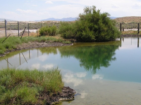
 TREGO HOT SPRINGS – Marker N-4
By 1860, Trego Hot Springs had been improved by Superintendent Lander. His crew constructed a channel and ran the water about 400 feet from the spring to the reservoir that they constructed. The sides of the reservoir were “paved” to prevent the water from percolating into the ground. At the springs, the water was hot enough to boil an egg hard in six minutes. After flowing to the reservoir, the water had cooled enough that it could be used for cooking, bathing, and watering livestock. Today, the hot springs area is very popular and and is often over-used. Photo by Allison Portello
¤ ¤ ¤ ¤ ¤ ¤ ¤ ¤ ¤ ¤ ¤ ¤
 CROSSING THE BLACK ROCK PLAYA SOUTHWEST FROM N-4
The playa is as level as a house floor and, according to one emigrant who crossed it, the playa is “sunbaked clay without a blade of grass or a bush.” The distance across the playa from Trego Hot Springs to Granite Springs is about 12 miles. Care must be exercised when traveling on the playa. When it is dry, vehicles driving on it will throw up large, blinding dust clouds which might hide other vehicles. When it is wet, vehicles can easily get stuck in the wet “clay”. On the day this photo was taken in early May, the playa was dry most of the way across it. Near the west side, however, the playa was wet and the route became slippery and potentially dangerous. Photo by Bob Black
¤ ¤ ¤ ¤ ¤ ¤ ¤ ¤ ¤ ¤ ¤ ¤
 THE SAND MOUND AT MARKER N-5
Maps of the area indicate that Coyote Spring is located here but emigrant diaries do not identify this spring as a source of water as they crossed the playa. Photo by Bob Black
¤ ¤ ¤ ¤ ¤ ¤ ¤ ¤ ¤ ¤ ¤ ¤
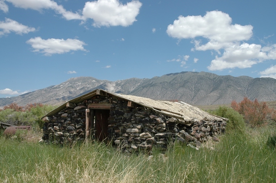
 GRANITE SPRINGS – Marker N-6
The first water the emigrants came to after crossing the playa was at Granite Springs. Some emigrants reported that a creek draining down from the Granite Range to the west was the water source. Whether it was a natural spring or a creek that the emigrants found here is uncertain. What is known is that a spring was improved by “paving” the sides and bottom and several tanks were built by Lander’s road crew in 1860. Grass was scarce near the playa as emigrants described having to make a difficult trip up Granite Creek to find sufficient grass to recruit their livestock. The Fort Granite ruins shown in the foreground, was temporarily occupied by the U.S. Army from 1865-1867. Photo by Alison Portello
¤ ¤ ¤ ¤ ¤ ¤ ¤ ¤ ¤ ¤ ¤
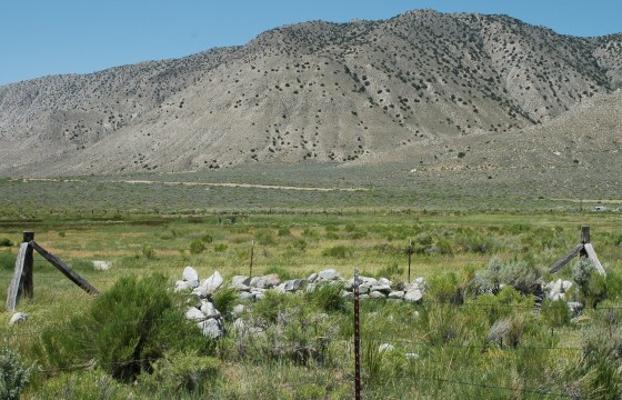
GREAT BOILING SPRINGS – MARKER N-7
Many emigrants traveling the Nobles Trail commented about the many hot springs located a short distance south of Granite Springs. These springs were large, deep and hot.Today, these springs are visible on private property located a short distance northwest of Gerlach, Nevada. Photo by Bob Black
¤ ¤ ¤ ¤ ¤ ¤ ¤ ¤ ¤ ¤ ¤ ¤
TRADING POST AT DEEP HOLE SPRINGS – MARKER N-8
After leaving the hot springs near present-day Gerlach, the emigrants traveled about eight miles in a northwest direction to Deep Hole Springs. Here they found ample water and forage and even a few supplies at the nearby trading post. The only remaining “deep hole” spring is located about 100 feet south of the trading post. Photo by Alison Portello
¤ ¤ ¤ ¤ ¤ ¤ ¤ ¤ ¤ ¤ ¤ ¤

TRAIL LEAVING THE PLAYA NEAR MARKER N-9A
When the emigrants left their haven at the springs, they had a choice of two routes to the next water. One route skirted the north side of the Smoke Creek Desert and passed by Wall Spring, located along the present day driving road. The other route headed southwest directly across the playa toward the foothills and Marker N-9A Photo by Bob Black
¤ ¤ ¤ ¤ ¤ ¤ ¤ ¤ ¤ ¤ ¤ ¤
 TRAIL HEADING SW FROM MARKER N-10
The two trail routes came together at the base of the hills near Marker N-9A. The combined trail then headed westerly around the spur of the mountain and then traveled southeast, passing Marker N-10, another five miles to Buffalo Springs. The Springs are in the line of trees visible in the upper left center of the photo. Photo by Alison Portello
¤ ¤ ¤ ¤ ¤ ¤ ¤ ¤ ¤ ¤ ¤ ¤
 TRAIL HEADING FROM BUFFALO SPRINGS TOWARD MARKER N-12
After the emigrants left this water source, which had been improved by Superintendent Lander in 1860 by digging a well and directing the water into wooden troughs, they traveled about seven miles to the edge of the desert near Marker N-12. Photo by Bob Black
¤ ¤ ¤ ¤ ¤ ¤ ¤ ¤ ¤ ¤ ¤ ¤
 TRAIL APPROACHING THE EDGE OF THE DESERT NEAR MARKER N-12
As the emigrants reached the edge of the desert, they knew that they only had to travel about four miles to the abundant clear, cold water in Smoke Creek. But first they had to cross the small range of hills through the saddle in the ridge directly ahead. Photo by Alison Portello
¤ ¤ ¤ ¤ ¤ ¤ ¤ ¤ ¤ ¤ ¤ ¤
TRAIL HEADING WESTERLY FROM MARKER N-12A TOWARD SMOKE CREEK
After the emigrants passed over the saddle, they found the travel fairly easy across the sandy, rolling terrain. Even though there were some difficult areas to traverse, the trip over this section of trail was generally considered to be an easy one. Photo by Bob Black
¤ ¤ ¤ ¤ ¤ ¤ ¤ ¤ ¤ ¤ ¤ ¤
 OX SHOE LAYING ON THE TRAIL WEST OF MARKER N-12A
As the emigrants traveled across the rolling hills, they frequently encountered short, steep rocky ridges. As the oxen struggled up the steep slopes, they occasionally pulled the worn steel shoes off their split hooves. Other artifacts like broken glass and pottery have often been seen along this section of original trail. This piece of trail makes a great hike! Photo by Bob Black
¤ ¤ ¤ ¤ ¤ ¤ ¤ ¤ ¤ ¤ ¤ ¤
 CAVE IN SMOKE CREEK CANYON AT MARKER N-13
The emigrants refreshed themselves and their cattle with the welcome water in Smoke Creek. A short distance before they reached the mouth of the Smoke Creek canyon, the emigrants passed a large cave located on the east side of the creek. They decided that the canyon was impassable without a lot of road building so they crossed the creek and climbed up onto a “bench.” They followed this bench for about a mile and then dropped back down to Smoke Creek. Photo by Alison Portello
¤ ¤ ¤ ¤ ¤ ¤ ¤ ¤ ¤ ¤ ¤ ¤
 THE TRAIL DROPPING DOWN TO SMOKE CREEK–MARKER N-14
The trail is barely visible on the hillside in the photo as it drops down to the creek. The emigrants turned up the creek and followed it northwest about 2 mile to a large meadow. Photo by Bob Black
¤ ¤ ¤ ¤ ¤ ¤ ¤ ¤ ¤ ¤ ¤ ¤
 INSTALLING THE NEW MARKER ON THE TRAIL AT N-15
After camping in the meadow near the confluence of Smoke Creek and Rush Creek, the emigrants traveled northwest about a mile and then climbed up to the saddle in the ridge. Rush Creek canyon was impassable so the detour over the ridge was necessary. Photo by Bob Black
¤ ¤ ¤ ¤ ¤ ¤ ¤ ¤ ¤ ¤ ¤ ¤
 TRAIL HEADING SOUTHWEST UP RUSH CR. NEAR MARKER N-16
After passing the ridge, the emigrants dropped down to Rush Creek at the Nevada-California state line. They followed the creek west and then south for about six miles as they traveled up the small drainage. Photo by Alison Portello
¤ ¤ ¤ ¤ ¤ ¤ ¤ ¤ ¤ ¤ ¤ ¤
 TRAIL HEADING SOUTHWEST TOWARD MUD SPRINGS FROM MARKER N-17
Once the emigrants reached the top of the Rush Creek drainage, they traveled southwest about four miles to Mud Springs, passing the location of Marker N-17 along the way. Photo by Alison Portello
¤ ¤ ¤ ¤ ¤ ¤ ¤ ¤ ¤ ¤ ¤ ¤
 TRAIL HEADING WEST ON THE “COBBLE STONE ROAD” NEAR MARKER N-19
After enjoying the plentiful, though muddy, water at Mud Springs the emigrants traveled west along the north slope of the foothills. Photo by Alison Portello
¤ ¤ ¤ ¤ ¤ ¤ ¤ ¤ ¤ ¤ ¤ ¤
 LOOKING NORTH ALONG THE TRAIL AT MARKER N-21
After traveling west from Mud Springs about ten miles on one of the worst rocky sections of the trail, the emigrants knew that they only had a few miles to go to reach Honey Lake Valley. Photo by Bob Black
¤ ¤ ¤ ¤ ¤ ¤ ¤ ¤ ¤ ¤ ¤ ¤
 LOOKING SOUTH TOWARD HONEY LAKE NEAR MARKER N-21
After traveling south about another mile, the emigrants got their first look at Honey Lake Valley. Photo by Bob Black
¤ ¤ ¤ ¤ ¤ ¤ ¤ ¤ ¤ ¤ ¤ ¤
 AT SHAFFER STATION (SITE) MARKER N-23
A trading post was established here by George Lathrop in 1859. The emigrants traveling through this part of the Honey Lake Valley before that time did not reach civilization until they reached Rooptown at the west end of the valley. Photo by Bob Black
¤ ¤ ¤ ¤ ¤ ¤ ¤ ¤ ¤ ¤ ¤ ¤
 SOLDIERS BRIDGE AT MARKER N-24
This marker, located just south of Litchfield along side Highway 395, is near a favorite camping area of the emigrants using the Nobles Trail along the Susan River in Honey Lake Valley. While a detachment of 50 U.S. Army troops was temporarily camping in this area in 1860, they constructed a log bridge across the Susan River. Photo by Bob Black
¤ ¤ ¤ ¤ ¤ ¤ ¤ ¤ ¤ ¤ ¤ ¤
 ROOPTOWN – LOCATED IN SUSANVILLE BEHIND MARKER N-26
After traveling west along the Susan River about ten miles from the Soldiers Bridge near Marker N-24, the emigrants arrived at the trading post which was operated by the Roop brothers commencing in 1854. Photo by Bob Black
¤ ¤ ¤ ¤ ¤ ¤ ¤ ¤ ¤ ¤ ¤ ¤
 BIG SPRINGS AT MARKER N-28
The emigrants traveled west about ten miles from Rooptown before they reached the first reliable water source. Nearly all the emigrants remarked on the spring and it was described as “a large spring of the finest water” and “the coldest water iimagionable (sic) ice water scarcley excepted.” Photo by Alison Portello
¤ ¤ ¤ ¤ ¤ ¤ ¤ ¤ ¤ ¤ ¤ ¤
 NANCY ALLEN GRAVE LOCATED AT MARKER N-30
This grave was located along the trail as it passed through a favorite emigrant camping area in the meadow along Bridge Creek. The original trail continued west to Feather Lake. A later alternative route, opened after 1855, turned northwest here and traveled up the series of prairies toward Pine Creek Valley. Photo by Bob Black
¤ ¤ ¤ ¤ ¤ ¤ ¤ ¤ ¤ ¤ ¤ ¤
 NANCY ANN ALLEN GRAVE HEADSTONE
A headstone made of local material was placed at the grave in 1857 and is still in place today. The still visible lettering says:
IN MEMORY OF NANCY ANN ALLEN
AGE 25 YR
No further information on Nancy Allen has been located, however, on June 23, 1865, Major Gortham Kimball, driving a flock of sheep to Idaho from California, wrote in his journal: “Found the grave of Mrs. Nancy Allen today. Some poor emigrant woman – on her way to California.”
In 2000, the original pipe fencing around the grave, which was erected by the Women’s Study Club of Westwood in 1924, was replaced by the current wood fencing. It was installed, along with a metal plate, by the CA-NV Chapter of the Oregon-California Trails Association. Photo by Alison Portello
¤ ¤ ¤ ¤ ¤ ¤ ¤ ¤ ¤ ¤ ¤ ¤
 THE COMBINED NOBLES-LASSEN TRAIL AS IT SKIRTS THE NORTH END OF
FEATHER LAKE NEAR MARKER N-31/L-32A
The orginal Nobles Trail routh going north and the Lassen Trail going south is shown by the line of rocks in the center of the photo. The trails came together along the west side of Feather Lake and shared the same trail north for the next five miles. This area was a heavily used camp area since there was abundant forage and water here. Photo by Alison Portello
¤ ¤ ¤ ¤ ¤ ¤ ¤ ¤ ¤ ¤ ¤ ¤
 JUNCTION OF THE ORIGINAL AND LATER ROUTE OF THE
NOBLES TRAIL AT MARKER N–32/L-32
The Y trail junction shown in the photo is where the later route of the Nobles Trail from Bridge Creek (the left leg of the Y) joined the original Nobles Trail (the right leg of the Y) coming north from Feather Lake. The Nobles Trail going north used the route followed by the earlier Lassen Trail as it traveled south on this section of trail. Photo by Bob Black
¤ ¤ ¤ ¤ ¤ ¤ ¤ ¤ ¤ ¤ ¤ ¤
 A SECTION OF THE TRAIL IN PINE CREEK VALLEY
HEADS NORTH TOWARD MARKER N-33/L-31
This section of the combined Nobles-Lassen Trail is located a short distance east of Highway 44. The trail route goes parallel to the highway for the length of Pine Creek Valley. Pine Creek was another of the favorite emigrant camping areas as it provided plenty of wood, water and grass. Photo by Bob Black
¤ ¤ ¤ ¤ ¤ ¤ ¤ ¤ ¤ ¤ ¤ ¤
 THE NOBLES TRAIL TRAVELING NORTHWEST AT MARKER N-35
NEAR POISON LAKE
The emigrants passing through this area often commented in their diaries about the size and density of the timber and how flat the terrain was. Poison Lake was so named for the inflammation caused by the bite of the small red spiders found on the surface of the lake. Photo by Alison Portello
¤ ¤ ¤ ¤ ¤ ¤ ¤ ¤ ¤ ¤ ¤ ¤
LASSEN PEAK FROM THE TRAIL NEAR MARKER N-39
This is the view that the emigrants, traveling on the alternate route of the Nobles Trail (1855 and later), had of Lassen Peak as they began the descent from the Hat Creek Rim to the flat below. Lassen Peak was called Mt. Saint Joseph by the emigrants. Photo by Bob Black
¤ ¤ ¤ ¤ ¤ ¤ ¤ ¤ ¤ ¤ ¤ ¤
 A LAVA CAVE IN HELL’S HALF ACRE NEAR MARKER N-40
This picture shows one of the caves that the emigrants, traveling across the rocky, lava ridged flat below the Hat Creek Rim, had to avoid. One emigrant remarked in his diary that the area “is the hardest & rockiest place that we have passed yet & the ground at the foot of the hill is called Hells Half Acre, but it is nearer 200 acres.” Photo by Alison Portello
¤ ¤ ¤ ¤ ¤ ¤ ¤ ¤ ¤ ¤ ¤ ¤
HAT CREEK AT MARKER N-41
After dropping down Hat Creek Hill and crossing over several miles of loose volcanic rock, the Nobles Trail travelers were delighted to find this rapid mountain stream called Hat Creek. This creek is located on the alternate Nobles Trail route which was also the route of the later California-Oregon Stage Road and the freight road to Fort Bidwell and Yreka. There is now a nice campground located next to the creek. Photo by Bob Black
¤ ¤ ¤ ¤ ¤ ¤ ¤ ¤ ¤ ¤ ¤ ¤
EMIGRANT FORD AT MARKER N-45
This ford across Hat Creek was located on the original route of the Nobles Trail. This route went south from the Butte Creek meadows to Black Butte Lake in the area that is now Lassen National Park. From the lake the trail ran west past Cinder Cone to Hat Creek. It followed Hat Creek north to the ford. After crossing the creek in ths area, the trail headed southwest to Nobles Pass in Lassen National Park. Photo by Bob Black
¤ ¤ ¤ ¤ ¤ ¤ ¤ ¤ ¤ ¤ ¤ ¤
 THE TRAIL NEAR TABLE MOUNTAIN AND MARKER N-47
The emigrants passing through this area on the alternate Noble Trail route, 1855 and later, were impressed with the size of the pine and fir trees found in this area. The trail continued southwest about another mile to the pass at Eskimo Hill on Highway 44.
Photo by Alison Portello
¤ ¤ ¤ ¤ ¤ ¤ ¤ ¤ ¤ ¤ ¤ ¤
 THE COMBINED TRAIL HEADING WEST NEAR MARKER N-49
The original trail of 1852-54, and the alternate trail of 1855 and later, came together about a mile north of this section of trail. In this area, the emigrants noted the heavy manzanita brush with its berries. Some of these folks mistakenly thought they were “razzberries.” The section of the trail west toward the next camping area at Deer Flat was sometimes referred to as the “Manzanita Chute”. Photo by Alison Portello
¤ ¤ ¤ ¤ ¤ ¤ ¤ ¤ ¤ ¤ ¤ ¤
 NOBLES TRAIL WEST OF MARKER N-58
The trail, now a wagon road, finally reached the Sacramento Valley at Bear Creek and Baker’s Place. This was a popular stopping place for emigrants. Later, the Dersch family purchased the property and continued to supply lodging and supplies to the travelers. From the Dersch Ranch, the road continued west toward Fort Reading. The later highway bridge in this photo is located on the old Nobles Trail. Photo by Bob Black
¤ ¤ ¤ ¤ ¤ ¤ ¤ ¤ ¤ ¤ ¤ ¤
 SITE OF THE EMIGRANT FERRY AT MARKER N-59
After passing Fort Reading, the trail continued southwest about three miles to the Sacramento River and the Emigrant Ferry. The ferry site is located just west of the new highway bridge. Photo by Bob Black
¤ ¤ ¤ ¤ ¤ ¤ ¤ ¤ ¤ ¤ ¤ ¤
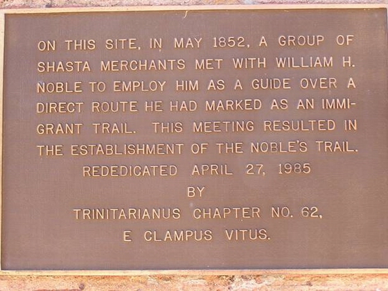
 END OF THE NOBLES TRAIL IN SHASTA CITY – MARKER N-61
After crossing the Sacramento River, some of the emigrants headed south to Red Bluff while others continued west and then northwest about seven miles to the “diggings” along Clear Creek. Many of the emigrants were not interested in mining and continued northwest another eight miles to the bustling little town of Shasta City where lodging and supplies were readily available.
The plate shown in the photo is located about a half-mile west of Marker N-61 on an old brick building across the street from the museum. Photo by Bob Black
We hope you have enjoyed this photo tour of the Nobles Trail. If you are interested in driving this trail, or just want some more information on the route and it’s history, be sure to get a copy of our book:
A GUIDE TO THE NOBLES TRAIL
Markers N-1 through N-61
